[ index | SAT ]
CORONA (1960-1972)
Concern about the the length of time it would take to achieve [a satellite that could scan its exposed film and return the imagery electronically] led to President Dwight Eisenhower's approval, on February 7, 1958, of a CIA program to develop a reconnaissance satellite. The CIA program, designated CORONA, focused on development of a satellite that would physically return its images in a canister.
It would take over a year, starting in 1959, and 14 launches before an operational CORONA spacecraft was placed in orbit. Nine of the first twelve launches carried a camera that was intended to photograph areas of the Soviet Union and other nations. All the flights ended in failure for one reason or another. The thirteenth mission, a diagnostic flight without camera equipment, was the first success - in that a canister was returned from space and recovered at sea.
Then on August 18 [1960], a CORONA was placed into orbit, orbited the Earth for a day, and returned its canister to earth, where it was snatched out the air by a specially equipped aircraft on August 19. The camera carried on that flight would be retroactively designated the KH-1 (KH for KEYHOLE) and was cable of producing images with resolution in the area of 25-40 feet - a far cry from what would be standard in only a few years. It did yield, however, more images of the Soviet Union in its single day of operation than did the entire U-2 program.
The next successful CORONA mission would be conducted on December 7, 1960. This time a more advanced camera system, the KH-2, would be on board. From that time, through the end of the CORONA program in 1972, there would be a succession of new camera systems - the KH-3, KH-4, KH-4A, and KH-4B - which produced higher-resolution images than their predecessors, ultimately resulting in a system that could yield images with approximately 5-6' resolution. In addition, two smaller programs - ARGON (for mapping) and LANYARD (motivated by a specific target in the Soviet Union) - operated during the years 1962-1964 and 1963 respectively. All together there were 145 missions, which yielded over 800,000 images of the Soviet Union and other areas of the world. (...) [cf: KH-11(1976)]
In February 1995, President Clinton signed an executive order that declassified those images.
-- Jeffrey T. Richelson: U.S. Satellite Imagery, 1960-1999
National Security Archive Electronic Briefing Book No. 13, April 14, 1999
src: http://www.gwu.edu/~nsarchiv/NSAEBB/NSAEBB13/index.html
====
CORONA is the name for the first operational space photo reconnaissance satellite. President Dwight David Eisenhower approved the project in February 1958. The project was conceived to take pictures in space of the Soviet Bloc countries and de-orbit the photographic film for processing and exploitation.
President Clinton signed an Executive Order on 22 February 1995, directing the declassification of intelligence imagery acquired by the first generation of U.S. photo-reconnaissance satellites; the systems code-named CORONA, ARGON and LANYARD. The order provides for the declassification of more than 860,000 images of the Earth's surface, collected between 1960 and 1972.
Early imagery collections were driven, in part, by the need to confirm purported developments in Soviet strategic missile capabilities. Worldwide photographic coverage was also used to produce maps and charts for the Department of Defense and other U.S. Government mapping programs. A speech made on 24 February 1995 by Admiral William O. Studeman, Acting Director of Central Intelligence Agency (CIA), recounts some of the important achievements of the historical satellite imagery reconnaissance programs.
CORONA spacecraft were built from 1959-72 by Lockheed Space Systems under Central Intelligence Agency and U.S. Air Force contracts spanning 145 launches that provided intelligence the government has called "virtually immeasurable."
CORONA's payload was a vertical-looking, reciprocating, 70-degree panoramic camera developed by Itek that exposed Eastman Kodak film by scanning at right angles to the line of flight. Resolution in early flight years was in the range of 35 to 40 feet. By 1972, CORONA delivered resolutions of six to 10 feet, routinely. In the 1970s, flights could remain on orbit for 19 days, provide accurate attitude, position, and mapping information, and return coverage of 8,400,000 nm2 per mission.
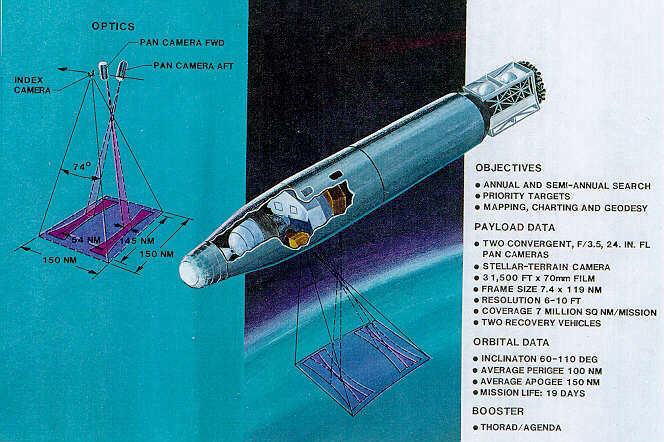
The intelligence community used the designators KH-1, KH-2, KH-3, KH-4, KH-4A, and KH-4B for the CORONA systems. The ARGON systems were designated KH-5 and the LANYARD systems KH-6. These KH (Keyhole) designators are used throughout this guide to describe system characteristics and accomplishments. Mission numbers were a principal means for indexing the reconnaissance imagery and associated collateral data.
Temporal Coverage
The first successful photographs from space were taken on 18 August 1960 by the KH-1 system and the last of the imagery of this collection was acquired on 31 May 1972 by the KH-4B system. The CORONA imagery was acquired by satellite-borne camera systems. The satellites were designed to deorbit a film capsule (referred to as a "bucket") from space with mid-air recovery of the returning capsule by a specially equipped aircraft. Early systems operated with a single bucket, while later systems were configured with two buckets; the KH-4A was the first satellite with multiple film buckets.
-- http://www.fas.org/spp/military/program/imint/corona.htm
Implemented by Christina Lindborg, 1997 Scoville Fellow
Cf. also:
CANYON (launched 1968) -- first US Comint satellite
RHYOLITE (launched 1972) -- geosynchronous orbit
KH-11 (launched 1976) -- low-flying satellite
[ index | SAT ]